Homework 10AGg2
To be completed by Friday 18/10/13
Read the information below and write down any questions that you may have.
Add a fact about the uses of fold mountains to this link:
To be completed by Monday 07/10/13
Read the information and watch the clips below please.
Landforms Created at Plate Boundaries
Fold Mountains
Watch this clip which shows the location of fold mountain ranges across the world and animations explaining their formation.
How Did They Form?
 Earth went through long periods of quiet time between Earth movements. Over the years, river carried sediment (soil and other materials) and deposited them in large depressions in the sea called geosynclines. Over millions of years, the sediment built up in layers and due to the pressure, compressed into sedimentary rock such as sandstone and limestone. This was thousands of metres thick in places. The sedimentary rocks were then forced upwards into a series of folds by the movement of tectonic plates towards each other. This happened at collision plate boundaries during a very active time in earths history, in which lots of movement was taking place. Two continental plates moved towards each other.
Sometimes we see simple upfolds in the rock (anticlines) and downfolds (synclines).
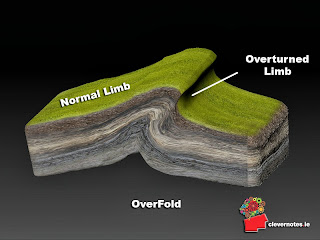
In some places the folds were pushed over on one side giving overfolds. See the diagram below.
Can you see any evidence of this process on the photograph below?
The Fold Mountain song to help you to remember the process!
Have any questions ready for Monday's lesson.
Miss Richmond
Re-cap for Plate Boundaries
Homework Questions 10AGg2 - Due Thursday 12/09/13
1. Using a diagram, describe the differences between the oceanic and continental crust (4 marks).
2. Study Figure 1 below which shows the Earth's tectonic plates and the places where earthquakes occur.
Question: Are the following statements about the distribution of earthquakes true or false? Write out the statement, then next to it write whether you think it is true or false.
Earthquakes occur in lines
Earthquakes never occur away from plate boundaries
Earthquakes occur around the edge of the Pacific Ocean
(3 Marks)
3. Are the following statements about continental crust and oceanic crust true or false? Answer this question in the same way as question 2.
Oceanic crust can be destroyed
Oceanic crust is generally lighter than continental crust
Continental crust is generally older than oceanic crust
(3 marks)
Take care with your presentation. Always use a sharp pencil and a ruler when drawing diagrams.
Remember, you will use these notes to revise for the exam.
Good Luck,
Miss Richmond
Welcome GCSE Geographers!
We are about to start our GCSE journey! Lot's of incredible topics and new skills to learn. We are very excited about this year and wish you every success!
_ _ _ _ _ _ _ _ _ _ _ _ _ _ _ _ _ _ _ _ _ _ _ _ _ _ _ _ _ _ _ _ _
Homework 05/07/13 Due Thursday 11/07/13
Landforms of Coastal Deposition
1 a. Name an example of a coastal bar. (1 mark)
b. State one similarity and one difference between bars and spits. (2 marks).
2 a. Study Figures 1 and 2 below. Describe two differences between the beaches.
(4 marks)
b. Explain the formation of beaches (4 marks)
Figure 1
Figure 2
3. Draw a labelled of Figure 3 to show the characteristics of the spit at Spurn
Point. (4 marks)
Check out this link to an animation on the formation of cliffs and wave-cut platforms:
Another useful website to help with your revision:
Restless Earth Case studies
Practice your map skills using these website:
Three Gorges Dam, China
 |
| Your papers are marked using level indicators. Marks are then awarded depending on which level you answer has reached. Remember to use case studies where appropriate Water on the Land Questions |
Bangladesh: Flooding in a LEDC
• Much of Bangladesh lies on a floodplain
• Over half of the country lies 6m below sea level.
• There are 3 major rivers: The Ganges, Brahmaputra and Meghna.
• Water in the rivers breach the levees.
• Most places receive between 1,800mm and 2,600mm rain a year.
• 80% of that total is concentrated into 4 or 5 months (June to September)
• It is a populous country of over 150 million people
Human
- The sources of the Ganges and Brahmaputra rivers are in Nepal and Tibet. In recent years, populations there have grown massively, causing removal of vast areas of forest to provide fuel, timber and grazing land. Deforestation in the Himalayas has increased soil erosion and overland flow. This leads to less interception and more water and silt in the river. More sediment in the river channels causes the river bed to rise, therefore reducing the capacity of the rivers.
- Bangladesh in an LEDC therefore its lack of money and heavy national dept means that little money is available to spend on flood protection methods/defenses and many existing defences lack upkeep and maintainance.
- The interval between big floods is shortening. It used to be 10-15 years, but the 2004 flood came only 6 years after a major flood in 1998. Many scientists believe that this is due to human activities contributing to climate change. Low-lying countries like Bangladesh will be the first to feel the effects from rising sea levels due to global warming.
Physical
- Bangladesh is a very low lying country with 80% of it being on a floodplain
- It receives a large amounts of water passing through it with 3 major rivers: The Ganges, Brahmaputra and Meghna. They converge in Bangladesh forming a huge delta.
- The region experiences a monsoon climate and annual torrential rains which often results in rivers exceeding their capacity and flooding
- In the spring, melting snow from the Himalayas further increases the flood risks
- Tropical cyclones from the Bay of Bengal bring heavy rain and storm waves in late summer
Boscastle Flood MEDC
Hydrograph
10AGg1 - Questions for homework, due in Friday 18/01/13
2. How could the effects differ between a tsunami occurring in an MEDC to one in an LEDC? [8 Marks]
3. Use a case study to describe the responses to a tsunami. [8 Marks]
I have had probems accessing the information you need to complete this homework so we will complete the fact file during the lesson!
Sorry guys!
Miss Richmond
Homework 10AGg1 - 19/09/12
Due in Friday 21/09/12
Complete your diagrams of the plate margins and complete the tables in your books.
Due in Friday 21/09/12
I have added the pages from the textbook to enable you to do this!
10AGg1 have produced some excellent models of the structure of the earth in the classroom!
Well done!
Spot the error on the model above!
Why do the Plates Move?
• Plates on our planet’s surface move because of the intense heat in the Earth’s core that causes molten rock in the mantle layer to move.
• It moves in a pattern called a convection currents that form when warm material rises, cools, and eventually sink down.
• As the cooled material sinks down, it is warmed and rises again.
Welcome Year 10 Geographers


No comments:
Post a Comment